Question.
Analyze the process of fluvial deposition and the resultant landforms with examples. ( UPPSC 1991)
Answer.
What are the fluvial landforms?
The landforms formed by running water are called fluvial topography. For example, valleys, deltas, oxbow lakes, and waterfalls are examples of fluvial landforms.
There are three processes involved in the formation of fluvial landforms, these are:
- Erosion
- Transportation
- Deposition
The eroded material is transported by running water in fluvial landforms.
The following are the basic terminologies:
Vertical erosion:
- The erosion of a riverbed or channel bed is called vertical erosion. Vertical erosion leads to deepening valleys.
Lateral erosion:
- Erosion of the river bed or channel wall is called lateral erosion. It leads to the widening of valleys.
Headward erosion:
- Erosion towards the mouth of the river is called headward erosion. It leads to an increase in the length of the river.
Running water in a heavy rainfall area is the most important agent of land degradation.
The following are two components of running water erosion:
The following are two components of running water erosion:
- Spread as a layer over the surface: This causes sheet erosion.
- Linear flow as a river: It forms valleys
Most of the landforms formed by running water are formed in the youth of the river.
- Over time, the river transforms the steep slope land into low slope land by erosion and deposition.
- Initially, the river forms valleys by doing vertical (downward) erosion of the land, and later stage through lateral erosion, the river turns hills and valleys into plains.
- Before the formation of valleys, the river first creates narrow rills on the surface of the land. The rills gradually develop into long and wide gullies. Later, the river deepens and widens the gullies to form different types of valleys.
The erosion cycle of landforms has three phases:
- Young stage
- Mature stage
- Old stage
Youth stage:
The following are characteristics of landforms:
- Poor integration of streams.
- Shallow V-shaped valleys
- No floodplain or narrow floodplain
- Flat marshes, swamps, and lakes
- Waterfall may exist.
Mature stage:
The following are characteristics:
The following are characteristics:
- Good integration of stream
- Deep V-shaped valleys
- Wider floodplain
- Flat and broad inter stream areas.
- The disappearance of Swamps and marshes.
- Disappearance of Waterfall
Old stage:
The following are characteristics:
The following are characteristics:
- Vast flood plains
- Oxbow lakes
- Natural levees
- Most of the landforms are slightly above sea level. Running water from the river erodes the landform and creates a featureless peneplain landform.
Erosional landforms created by running water
The following are erosional fluvial landforms :
- Valleys
- Potholes and Plunged pool
- River Terrace
- Waterfall
- Meanders
- Oxbow lake
- Braided Channel
Valleys:
The valleys start with narrow and small rills, after vertical erosion it deepens, later after lateral erosion, long and wide gullies, then form different types of valleys. |
| Types of Valley |
Types of valleys:
- V-shaped valleys
- Gorge
- Canyon
Gorge:
- Gorge is a deep valley with steep straight sides.
- Gorge has equal width of its top and bottom.
- It is generally formed in the region where hard rocks are present.
Canyons:
- It has a Steep side but is not as straight as the gorge.
- The tops are wider than the bottom.
- Canyons are formed in the region where sedimentary rocks are prominent.
Potholes and Plunged pool:
- In the hilly areas, small rock pieces in the river bed get stuck in small pits and move around in a circular form, which is called a Pothole.
- Gradually the size of the potholes increases and two or more potholes join together to form a deep pool.
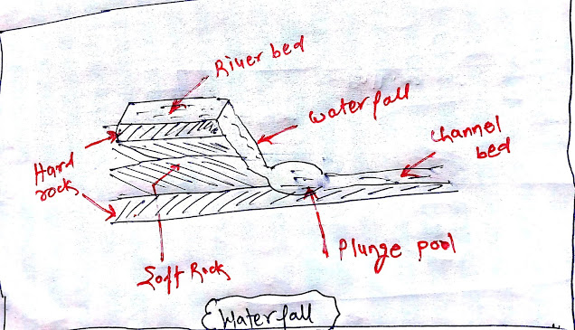
- Huge Plunged pools are found at the base of the waterfall
 |
| Potholes and Plunged Pool |
Meanders:
- When the rivers enter the plains, they turn and flow in a curvilinear way; These sinuous river streams are known as meandering.
- When a river flows over a plain with low slopes, the lateral erosion is greater than the vertical erosion, resulting in a curvilinear course of the river.
- In areas with hard rocks, when the river forms a deep and wide estuary, it is called an entrenched meanders.
Oxbow lake:
- Due to frequent erosion and deposition on the banks of the meandering river; Over time, a small part of the meandering river gets cut off from the main river channel. Due to the filling of water in this cut part, it is called Oxbow Lake (Gokhur Lake).
River terrace:
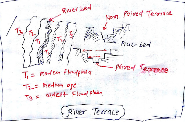
River terraces mark the surface of the old floodplains. The rivers form river terraces by making vertical erosion on their own deposit plains.
River terraces can be of two types:- Paired terrace
- Non Paired terrace
 |
| River Terrace |
Paired Terrace:
- If the river terraces are of equal height on both sides of the river, then this form is called paired terrace.
- If the river terraces have unequal heights on both sides of the river, then this form is called a non-paired terrace.
Reasons for Terrace formation:
- The terrace is resulted due to receding water offering peak flow.
- Change in hydrological regime due to climate change.
- The tectonic uplifting of land.
- Sea level changes in the case of the river closer to the sea.
Waterfall landform:
When the river falls from soft rock to hard rock, it forms a waterfall.
 |
| waterfall |
Kunchikal waterfalls:
- It is the highest step that falls in India formed in the Varahi river in Karnataka. It is about 455 meters.
Nohkalikas waterfalls:
- It is the tallest waterfall in India in Meghalaya.
The highest waterfall in the world?
- Angel waterfalls: It is the tallest waterfall in the world. It is in Venezuela and is about 979 meters high.
Other waterfalls:
- Niagara waterfalls; is on the border between the USA and Canada.
- Victoria waterfalls; It is on the border between Zambia and Zimbabwe.
Braided channel:
- When the main river channel water is distributed into different smaller channels, the formation of such a pattern is called the braided channel.
- Deposition of coarser material by river channel leads to the formation of a central bar, which leads to the diversion of the flow of water.
- Braided channels are formed due to the creation of bars on the river beds.
 |
| Braided Channel |
Depositional landforms by running Water
The following depositional fluvial landforms.
- Alluvial Fans
- Flood plains
- Levees
- Delta
Alluvial fans:
- Alluvial Fans are formed when a river flows from a high slope area and enters a low slope plain.
- Often, when a river flows from a mountainous region and enters the plain, they are unable to carry the eroded material they bring with them and deposit the eroded material in the shape of a cone. Which we call alluvial fans.
- For example, all Himalayan rivers make alluvial fans when they enter plain areas.
 |
| Alluvial Fans |
Flood Plains:
- Flood plains are the main landform of river deposition. When a river enters a steep slope from a hilly area, it deposits the eroded material in large numbers to form a flood plain.
- Flood deposits are made up of finer materials such as clay and silt.
- Channel deposits are made up of coarser deposits.
Levees:
- Raised banks are called levees. Natural levees are found along with banks of the larger rivers. They are low, linear, and parallel ridge of course deposits.
- Point bars are also known as meander bars. They are found on the concave side of the meander of large rivers. Point bars are the sediments deposited by flowing water on the concave side of a large river's meander.
Deltas:
- At the mouth of the river, the river begins to split into several streams called distributaries. The river slows down and starts depositing its weight such as silt, and sediment. Each distributary makes its own mouth; The collection of sediments from all the mouths forms a delta.
- The delta is like an alluvial fan but develops at the mouth of a river. Delta is the deposition of erosive material carried by the river at the mouth.
- In the delta region, heavy material accumulates first and finer material such as silt and clay goes into the sea.
You may like also:


3 Comments
Click here for CommentsNyc
ReplyAwesome content Sir🙏
ReplyShort, easy and very good content sir 👍 thank you so much 🙏
ReplyConversionConversion EmoticonEmoticon