Sources of Ocean water temperature:
The following are two major sources of ocean temperature:
- Surface Water gets heat from Sun and temperature gets diffused or reached depth due to convection.
- Bottom water gets heat from volcanic activities in oceanic ridges areas.
Measurement of Oceanic temperature:
- A bathythermograph is used to measure the temperature of ocean depth.
- The temperature of the Ocean Surface is measured by Satellites by a macro wave Radiometer.
The process of cooling and heating ocean water is slower as compared to land as Sun rays penetrate more in water than on land and water molecules diffuse the energy more quickly than on land.
The following factors affect the temperature distribution of the ocean water:
- Latitude
- Unequal distribution of land and water
- Prevailing Winds
- Ocean Current
- Enclosed sea
Latitude:
- The amount of Insolation get decreases from the equator to the poles and thus the temperature of surface water get decreases from the equator to the poles.
Unequal distribution of land and water:
- Water gets heat indirectly from land and as the northern hemispheres have more land as compared to the southern hemisphere; Northern hemisphere water is warmer than southern hemisphere ocean water.
Prevailing Winds:
- Winds blowing from land to ocean water drive warm water away from the coast leading to the upwelling of water from below leading to a longitudinal distribution of ocean water.
Ocean Current:
- Warm ocean current increases the temperature in cold areas. For example, the North Atlantic ocean drift current or Gulf Stream current increases the temperature in western Europe and easter North America.
- Cold ocean currents decrease the temperature in warm areas. For example, the Labrador current decreases the temperature on the North East coast of North America.
Enclosed sea:
- In the lower latitude, the Enclosed sea has a relatively higher temperature than the open sea.
- In the higher latitude, the enclosed sea has lower temperatures than the open or surrounding sea.
Horizontal distribution of the ocean temperature:
- The average temperature of surface temperature of tropical water is around 27 degrees C.
- The gradual decrease of temperature experienced from the equator to the poles.
- The rate of decrease of temperature with increasing latitude is generally 0.5 degrees C per latitude.
- The average temperature is 22 degrees C in 20 degrees latitudes.
- The average temperature is 14 degrees C in 40 degrees latitudes.
- 0 degrees C in poles.
- The highest temperature is not recorded at the equator because of the following reasons:
- Dense cloud formation in the equatorial region reduces the sun's heat.
- The Equator gets convection rainfall all over the years, hence increasing the fresh water in the equatorial region. As freshwater has relatively cooler than saltwater.
- Equatorial rivers such as Amazon and the African river add huge freshwater to the ocean.
- The highest temperature is recorded slightly north of the equators.
- The northern hemisphere ocean has relatively more temperatures than southern ocean waters as land is more extensively found in the northern hemisphere.
Vertical distribution of Ocean temperatures:
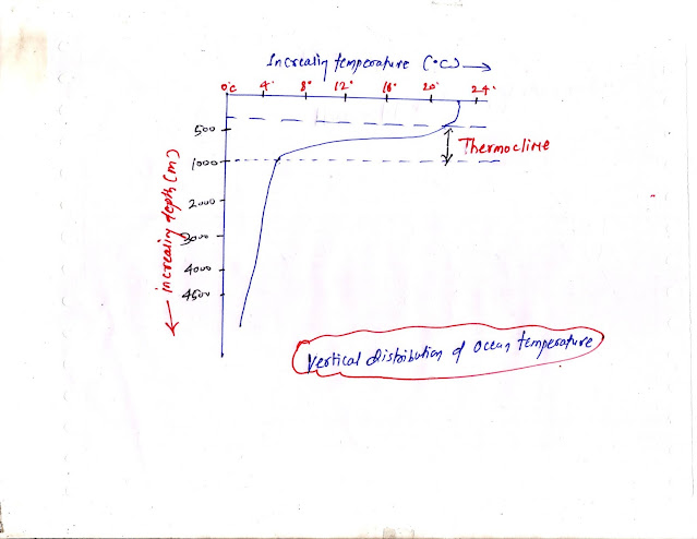
The vertical distribution of ocean temperatures can be shown in the " temperature-depth profile". It can be categorized into three Layers in the lower and middle latitudes.
- First Layer( Top Layer up to 500 meters in depth)
- Second Layer or Thermocline Layer ( from 500 meters to 1000 meters)
- Third Layers( from 1000 meters to the bottom of the ocean)
First Layer( Top Layer up to 500 meters in depth):
- Average temperature experiences between 20 degrees to 25 degrees C.
- It present all the time in tropical water but in the middle latitudes, it is present in the summer season only.
Second Layer or Thermocline Layer ( from 500 meters to 1000 meters):
- It is also called the thermoclines layer and it is characterized by the rapid decrease in the temperature with increasing depth.
Third Layers( from 1000 meters to the bottom of the ocean):
- It is below the thermocline layer and extends up to the bottom of the ocean.
- The rate of decrease in temperature is very low with the increase in depth.
- Temperature is very close to 0 degrees in the Arctic and Antarctic circles.


ConversionConversion EmoticonEmoticon