Question.
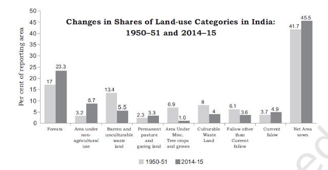
Compare the changes in land use between 1950–57 and 2014–15 in India.
(NCERT class 12 geography, India People and Economy, Chapter-5. Land Resources and Agriculture)
Answer.
Different types of land are suitable for different uses. For example, fertile land is used for agricultural purposes, rough terrain is used for forests and trees, and some land is used for rivers, ponds, roads, buildings, etc.
The land use records in India are maintained by the Land Revenue Department. Following are the classification of land use maintained by the Land Revenue Department:
- The area under forests
- Barren and wasted land
- The area under non-agricultural use
- The area under permanent pastures and grazing land
- The area under various tree crops and groves
- Cultivable waste land
- Current fallow land
- Other than the current fallow land
- Net sown area
The change in land use in the above categories of land use in India between 1950-57 and 2014-15 is depicted in the figure below[ source: NCERT].
Following is a comparative description of the data on change in land use in India between 1950-57 and 2014-15:
- The area under notified forest [actual forest cover has decreased] increased from 17 percent to 23.3 percent.
- Non-agricultural land use has the highest rate of growth, rising from 3.2% to 8.7%. The increase in land use under this category is due to an increase in urbanization, expansion of industries and service sectors as well as rural settlement.
- Barren and wasted land use has decreased from 13.4% to 5.5%, and land under these categories has been mostly converted into urban and rural settlements.
- Land use under permanent pasture and grazing land increased from 2.3% to 3.3% due to the variability of rainfall and desertification.
- The area under "Miscellaneous tree crops and groves" has come down from 6.9% to 1% as this category of land has been shifted for agriculture, construction, and human settlement.
- Illegal encroachment and population pressure have led to a decline in the share of land use under the categories of "cultivable wasteland" and "fallow land other than current fallow".
- Due to the variability of rainfall and change in agricultural patterns, the current fallow land area has increased from 3.7 to 4.9%.
- The "net sown area" has increased from 41.7% to 45.5% due to an increase in population pressure and the conversion of barren wasteland to agricultural land.
You may like also:

ConversionConversion EmoticonEmoticon